- Αρχική Σελίδα
- →
- Κεντρική Βιβλιοθήκη Ε.Μ.Π.
- →
- Ιδρυματικό Αποθετήριο
- →
- Διπλωματικές Εργασίες
- →
- Εμφάνιση Τεκμηρίου
JavaScript is disabled for your browser. Some features of this site may not work without it.
| dc.contributor.advisor | Γκανιάτσας, Βασίλειος | el |
| dc.contributor.author | Χορτογιάννης, Αλέξιος Πολύκαρπος Ν.
|
el |
| dc.contributor.author | Chortogiannis, Alexios Polykarpos N.
|
en |
| dc.date.accessioned | 2012-12-17T12:38:43Z | |
| dc.date.available | 2012-12-17T12:38:43Z | |
| dc.date.copyright | 2012-12-17 | - |
| dc.date.issued | 2012-12-17 | |
| dc.date.submitted | 2012-12-17 | - |
| dc.identifier.uri | https://dspace.lib.ntua.gr/xmlui/handle/123456789/7158 | |
| dc.identifier.uri | http://dx.doi.org/10.26240/heal.ntua.4654 | |
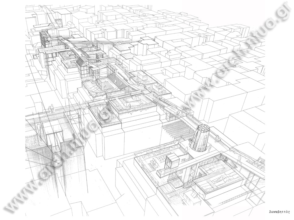
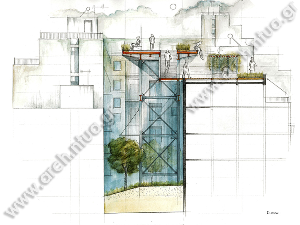
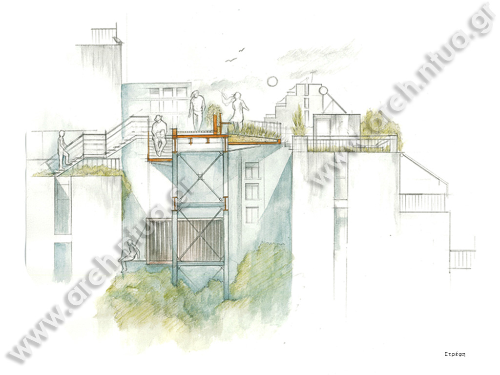
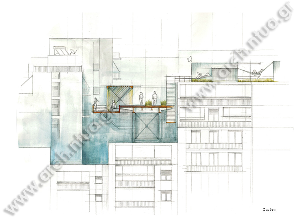
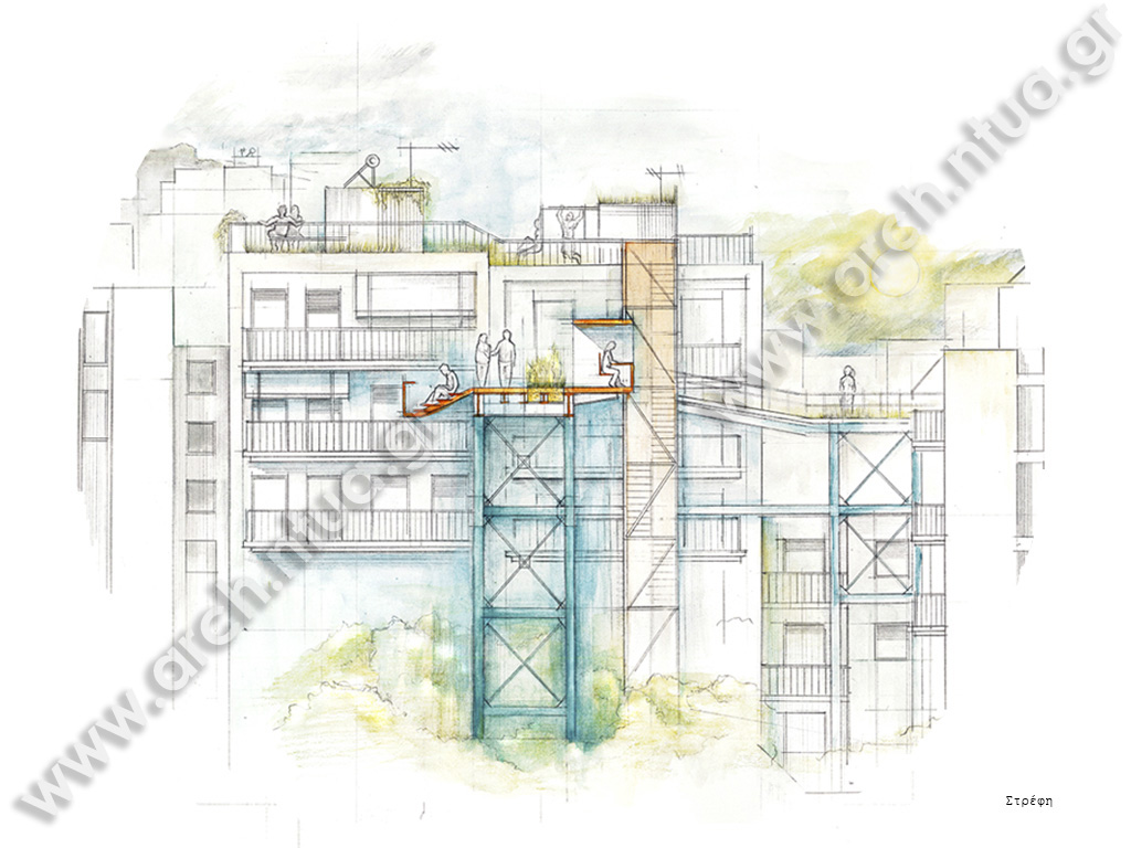
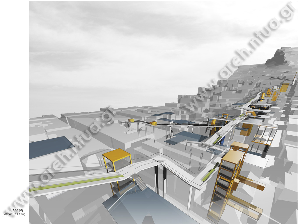
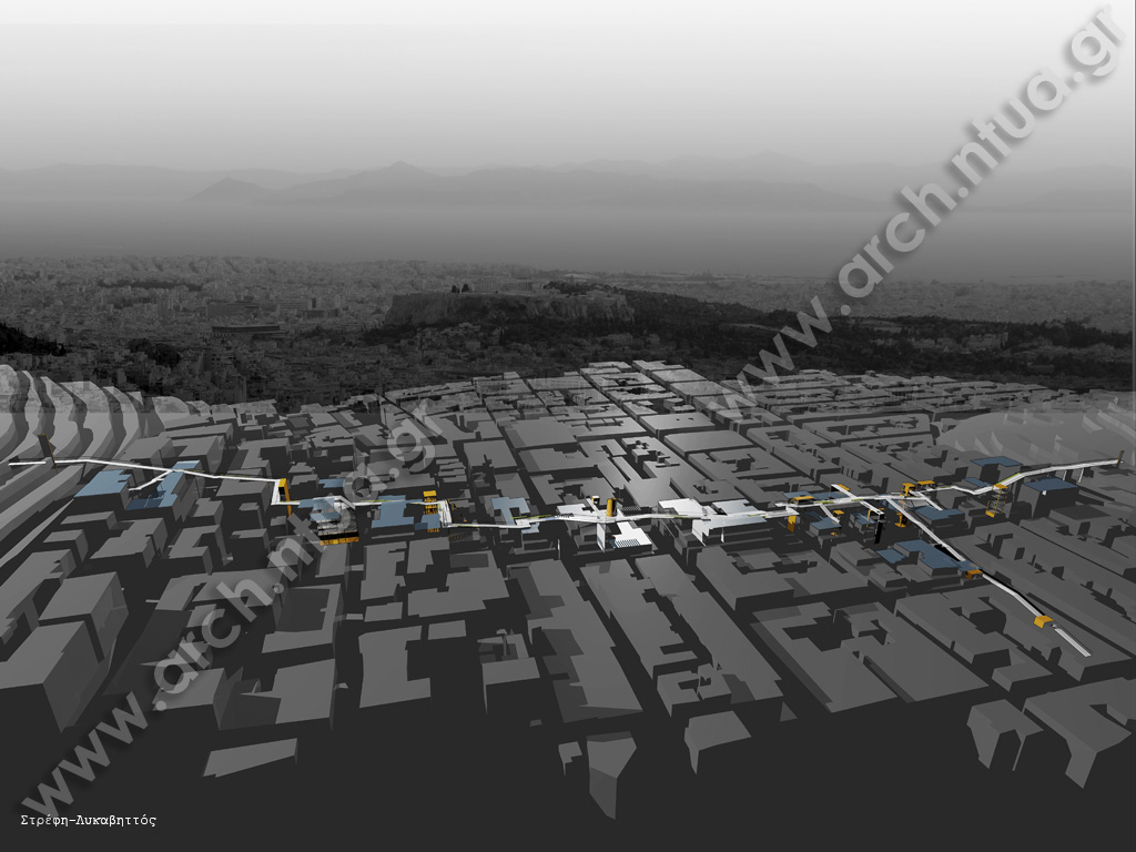
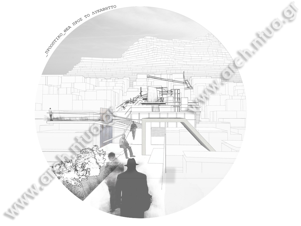
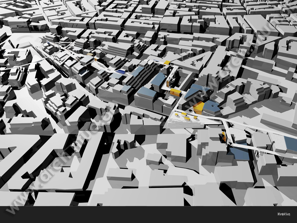
| dc.description.abstract | Πρόταση δικτύου υποδομής στη 5η όψη της Αθήνας Στόχος της ερευνητικής διαδικασίας είναι η οικοιοποίηση των δωμάτων της Αθήνας μέσα από τη δημιουργία ενός δικτύου υποδομής πάνω στο skyline της πόλης.Κατά τη διάρκεια του περασμένου αιώνα η πόλη της Αθήνας μετατράπηκε σε σύνολα πολυκατοικιών, στα οποία συγκεντρώνεται ο μισός πληθυσμός της χώρας.Ο τύπος της πολυκατοικίας έχει απορροφήσει το δημόσιο χώρο της πόλης και τον έχει κατακερματίσει σε χιλιάδες μικρές ιδιοκτησίες. Οι ελεύθεροι χώροι είναι το απομεινάρι του δομημένου περιβάλλοντος.Η ζωή εκτελίσσεται στο επίπεδο του δρόμου σε συνεχή διασταύρωση με τροχοφόρα και τα τελαυταία χρόνια κάτω από αυτό λόγω του μετρό. Από τα παραπάνω οδηγούμαστε στο εξής ερώτημα: πως γίνεται, ενώ δεν υπάρχουν επαρκείς ελεύθεροι χώροι, μια μεγάλη επιφάνεια του δομημένου περιβάλλοντος να παραμένει ανεκμετάλευτη. Και φυσικά μιλάμε για τα δώματα των πολυκατοκιών, στα οποία μπορεί κανείς να βρει μόνο κεραίες τηλεόρασης και ηλιακούς, ως σύμβολα της επικοινωνίας μας με τον ουρανό και το άπειρο.Η δημιουργία καταστάσεων και ανθρωπίνων δραστηριοτήτων στα δώματα προϋποθέτει την εύρεση ενός σωστού αχιτεκτονικού λεξιλογίου και την επιλογή των κατάλληλων συνθετικών εργαλείων. Αρχικά γίνεται η ανάλυση πέντε βασικών χαρακτηριστικών του αθηναϊκού αστικού ιστού τα οποία αντιστοιχούν σε πέντα βασικά συνθετικά εργαλεία.Το πρώτο είναι το 'συνεχές χαλί' που σχηματίζουν τα δώματα των πολυκατοικιών. Η πυκνότητα είναι τόσο μεγάλη που θα μπορούσαμε να φανταστούμε τα δώματα ως ένα ενιαίο χωρικό σύστημα.Το δεύτερο είναι η μικρή κλίμακα των οικοδομικών τετραγώνων. Το επίπεδο των δωμάτων και το επίπεδο του δρόμου είναι πολύ κοντά και θα μπορούσε να υπάρχει μια επικοινωνιακή σχέση μεταξύ τους.Το τρίτο χαρακτηριστικό αφορά τον συνεχή και ζωντανό δημόσιο χώρο μέσα και έξω από τη πολυκατοικία με εξαίρεση το δώμα στο οποίο δε λαμβάνει μέρος σχεδόν καμία δραστηριότητα. Αυτό οφείλεται στο ότι το δώμα δεν αποτελεί μέρος μια ευρύτερης ροϊκότητας και κίνησης όπως τα μαγαζιά στο επίπεδο του δρόμου.Το τέταρτο χαρακτηριστικό αφορά τη θέα πάνω από το αστικό τοπίο και το πέμπτο τη μίξη των χρήσεων ανά οικοδομικό τετράγωνο, κάτι το οποίο διευκολύνει την δημιουρία νέων χρήσεων στα δώματα αυτών. Για την εφαρμογή των παραπάνω θεωρητικών συνθετικών εργαλείων τέθηκαν δύο βασικά κριτήρια για την επιλογή του τόπου. Το πρώτο είναι η γειτνίαση με τους λόφους της Αθήνας και το δεύτερο η πυκνότητα . Με βάση τα παραπάνω η περιοχές που επιλέχθησαν είναι η Νεάπολη Εξαρχείων, που βρίσκεται ανάμεσα από το λόφο του Στρέφη και το Λυκαβηττό και η Κυψέλη που έχει έντονο αστικό ανάγλυφο και εκτείνεται ως τις παρυφές των Τουρκοβουνίων. Βασική ιδέα είναι η σύνδεση των λόφων και κάποιων δημόσιων χώρων με τα δώματα των πολυκατοικιών. Για να επιτευχθεί αυτό ακολουθούνται τρεις βασικές στρατηγικές κατευθύνσεις. Η πρώτη είναι η δημιουργία μιας διαδρομής-δίκτυο που θα συνδέει τους λόφους με τα τα δώματα των οικοδομικών τετραγώνων και θα στηρίζεται σε μεταλλικούς πυλώνες που θα τοποθετούνται στους ακάλυπτους και στο δρόμο(π.χ High Line). Η δεύτερη αφορά τη δημιουργία πράσινων δωμάτων τα οποία αν επιθυμούν θα συνδέοναι με το δίκτυο. Και η τρίτη την προσάρτηση σε αυτή την υποδομή βοηθητικών χώρων αναψυχής υπό τη μορφή λυόμενων κατασκευών και container. Στη Κυψέλη έγινε η εφαρμογή του παραπάνω συστήματος για την σύνδεση της πλατείας Κυψέλης και των Τουρκοβουνίων ακολουθώντας το παλιό ίχνος του ρέματος της Φωκίωνος Νέγρη. Στη Ν.Εξαρχείων γίνεται η προσπάθεια σύνδεσης του λόφου του Στρέφη με το λόφο του Λυκαβηττού. Και στις δύο περιπτώσεις η θέα προς τα φυσικά όρια του λεκανοπεδίου, τα ιστορικά μνημεία και τους λόφους καθώς και η θέα της κορυφογραμμής της πόλης πάνω στην οποία κινούμαι αποτελούν βασικά στοιχεία της παρούσας διπλωματικής εργασίας. | el |
| dc.description.abstract | Proposal of an infrastructure network on the rooftops of Athens The current research aims to the appropriation of the rooftops in contemporary Athens through the creation of an infrastructure network on its skyline.Over the past century, the city of Athens has turned into an accumulation of sets of "polykatoikias", its typical building type unit, containing half of the population of Greece.This building type has absorbed the city's public space, frittering it in innumerable small properties, at the same time widowing the free, public space to the leftover of the built environment.Public life unfolds in the street level, in direct contact with vehicles, and recently even lower, under it, due to the creation of the city's subway. Given the factors mentioned above,the research hypothesis arises:how is it possible that, given the lack of sufficient free spaces, a large surface of the built environment remains unexploited. This hypothesis obviously refers to the rooftops of polykatoikias, where only solar water heaters and antennas are found, symbols of our communication with the sky and the infinite. The creation of a human activities on the roofs presupposes the definition of the correct "architectural vocabulary" and the choice of the appropriate design tools.Firstly, five basic characteristic of Athens' urban landscape are analyzed,each corresponding to five principal design tools.The first is the "continuous carpet", the surface created by the roofs of polykatoikias. The density is high enough to allow us to imagine them as a single spatial system.Secondly, the small scale of athenian blocks is being outlined. The level of the roofs is close to the street level, enabling the creation of a potential communication between them.The third characteristic refers to the vital and continuous public space in the inner and outer parts of the polykatoikia, apart from the roof, where no activities take place. The reason for this lies on the fact that the roof is not part of a general flux and movement, as are the stores, set in the street level.The view offered above the urban landscape is the fourth characteristic, while the fifth relates to the mix of uses, observed in each block. This fact enhances the creation of new activities and uses on the roofs. After having theoretically analyzed the synthetic tools, two principal criteria are set, in order to define the place of their application. The first is the vicinity with Athens' hills, while the second one the density. Given these criteria, the chosen places of application are Neapoli Exarcheion, the area between Strefi and Lykavittos hills, and Kypseli, having a significantly intense urban repousse and spreading to the edges of Tourkovounia mountain.The principal idea of the project is the connection of the hills and some public spaces with the roofs of polykatoikias. In order to achieve this, three basic strategic guidelines are followed. The first is the creation of a path, a network connecting the hills with the roofs of the blocks, based on metallic pylons, which are placed either in the blocks' voids or on the street (i.e. High Line,NY). The second refers to the creation of green roofs, which, according to their willingness, could potentially be connected to the network. Finally, the third guideline relates to the addition of auxiliary entertainment places on the network, by the form of prefabricated constructions or containers. In the area of Kypseli, this system was applied in order to connect Kypseli Square and Tourkovounia mountain, following the trace of Fokionos Negri stream. In Neapoli Exarcheion, on the other hand, an attempt to connect Strefi and Lykavittos hills was designed. In both occasions of this research, the view to the natural limits of the Attica basin, the historical monuments and the hills, as well as the view of the skyline of the city, in which one is moving, have constituted principal elements of design. | en |
| dc.description.statementofresponsibility | Αλέξιος Πολύκαρπος Ν. Χορτογιάννης | el |
| dc.language.iso | el | en |
| dc.rights | ETDFree-policy.xml | en |
| dc.subject | Δώμα | el |
| dc.subject | Δίκτυα υποδομής | el |
| dc.subject | Αθήνα | el |
| dc.subject | Πέμπτη όψη | el |
| dc.subject | Πολυκατοικίες | el |
| dc.subject | Λόφοι | el |
| dc.subject | Αστικό ανάγλυφο | el |
| dc.subject | Rooftop | en |
| dc.subject | Infrastructure | en |
| dc.subject | Network | en |
| dc.subject | Athens | en |
| dc.subject | Apartment houses | en |
| dc.subject | Hills | en |
| dc.subject | Urban landscape | en |
| dc.title | Πρόταση δικτύου υποδομής στην πέμπτη όψη της Αθήνας | el |
| dc.title.alternative | Proposal of an infrastructure network on the rooftops of Athens | en |
| dc.type | bachelorThesis | el (en) |
| dc.date.accepted | 2012-10-30 | - |
| dc.date.modified | 2012-12-17 | - |
| dc.contributor.advisorcommitteemember | Μπελαβίλας, Νικόλαος | el |
| dc.contributor.advisorcommitteemember | Βασιλάτος, Παναγιώτης | el |
| dc.contributor.advisorcommitteemember | Νουκάκη Μπαμπάλου, Παρασκευή | el |
| dc.contributor.department | Εθνικό Μετσόβιο Πολυτεχνείο. Σχολή Αρχιτεκτόνων Μηχανικών. Τομέας Αρχιτεκτονικού Σχεδιασμού | el |
| dc.date.recordmanipulation.recordcreated | 2012-12-17 | - |
| dc.date.recordmanipulation.recordmodified | 2012-12-17 | - |
Αρχεία σε αυτό το τεκμήριο
Αυτό το τεκμήριο εμφανίζεται στην ακόλουθη συλλογή(ές)
-
Διπλωματικές Εργασίες [18981]


