- DSpace Home
- →
- Κεντρική Βιβλιοθήκη Ε.Μ.Π.
- →
- Ιδρυματικό Αποθετήριο
- →
- Μεταπτυχιακές Εργασίες
- →
- View Item
HEAL DSpace
Το υδρογεωλογικό καθεστώς της ευρύτερης περιοχής της λεκάνης Βάρης-Βάρκιζας
DSpace/Manakin Repository
JavaScript is disabled for your browser. Some features of this site may not work without it.
| dc.contributor.advisor | Κουμαντάκης, Ιωάννης | el |
| dc.contributor.author | Πάντου, Χριστίνα Κ.
|
el |
| dc.contributor.author | Pantou, Christina K.
|
en |
| dc.date.accessioned | 2013-04-05T07:45:43Z | |
| dc.date.available | 2013-04-05T07:45:43Z | |
| dc.date.copyright | 2013-04-01 | - |
| dc.date.issued | 2013-04-05 | |
| dc.date.submitted | 2013-04-01 | - |
| dc.identifier.uri | https://dspace.lib.ntua.gr/xmlui/handle/123456789/7918 | |
| dc.identifier.uri | http://dx.doi.org/10.26240/heal.ntua.3168 | |
| dc.description | 233 σ. | el |
| dc.description | Εθνικό Μετσόβιο Πολυτεχνείο--Μεταπτυχιακή Εργασία. Διεπιστημονικό-Διατμηματικό Πρόγραμμα Μεταπτυχιακών Σπουδών (Δ.Π.Μ.Σ.) “Επιστήμη και Τεχνολογία Υδατικών Πόρων” | el |
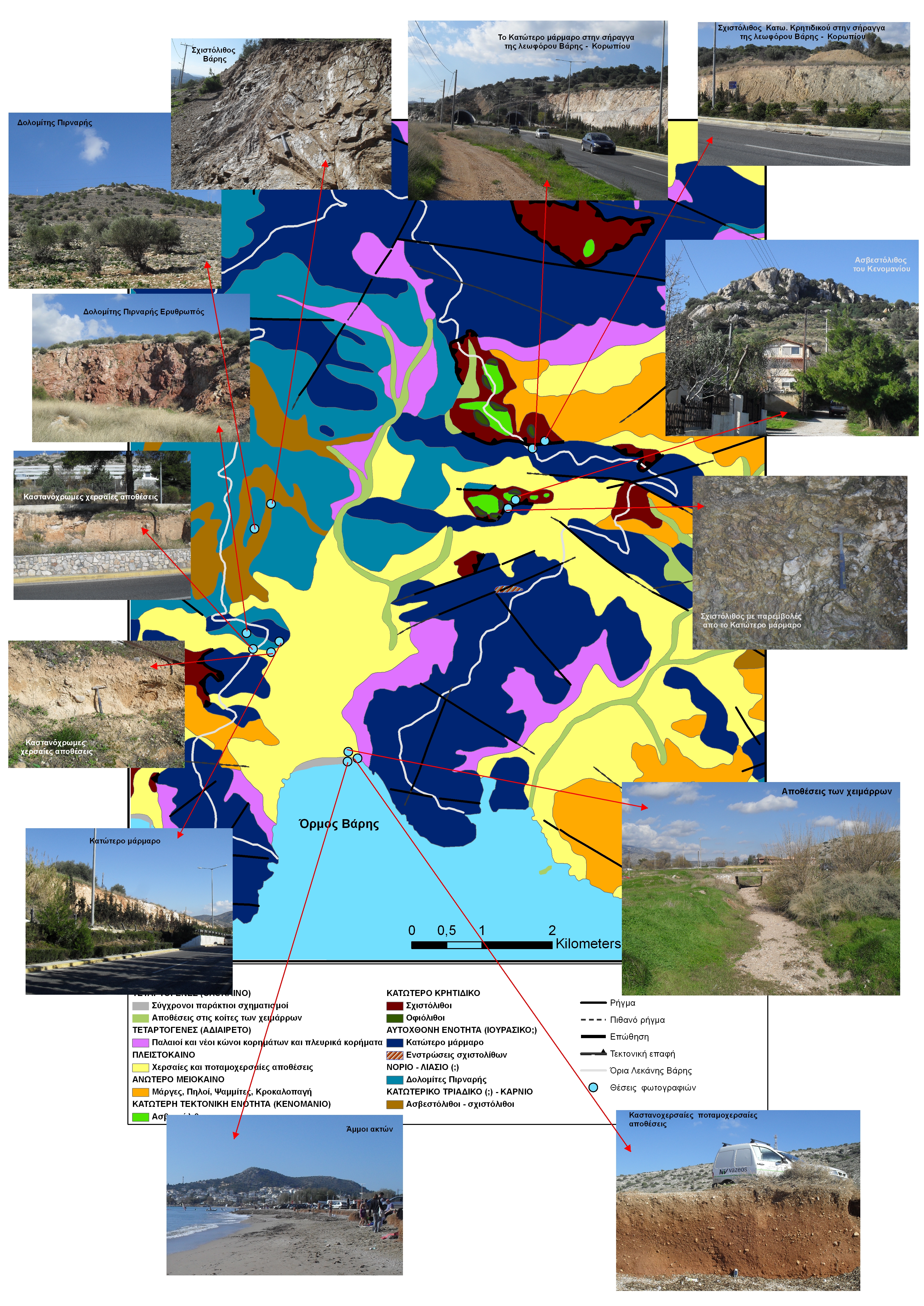
| dc.description.abstract | Αντικείμενο της παρούσας εργασίας είναι η έρευνα του υδρογεωλογικού καθεστώτος της ευρύτερης περιοχής της λεκάνης Βάρης – Βάρκιζας, δίνοντας ιδιαίτερη έμφαση στη ποιότητα των υπόγειων υδατικών της πόρων. Η λεκάνη της Βάρη έχει έκταση 32,09 km2. Η περιοχή της Βάρης, είναι δομημένη ανάμεσα στους νότιους ορεινούς όγκους του Υμηττού, κοντά στις ακτές του Σαρωνικού. Νοτιοδυτικά συνορεύει με τον Δήμο Βουλιαγμένης, βορειοδυτικά με τον Δήμο Βούλας, ενώ βόρεια και ανατολικά με τον Δήμο Κρωπίας, ενώ ανατολικά με την Άνοιξη και την Αγία Μαρίνα Κορωπίου. Νότια βρέχεται από τον όρμο της Βάρκιζας, όπου είναι και η παραθαλάσσια ζώνη της Βάρης. Πραγματοποιήθηκε, δειγματοληψία υπόγειων νερών, στην ευρύτερη περιοχή της λεκάνης Βάρης - Βάρκιζας, κατά την διάρκεια των περιόδων 19-20 Ιουλίου και 6-7 Νοεμβρίου 2012 (που αντιστοιχεί στην περίοδο της χαμηλής στάθμης του υδροφόρου). Πιο συγκεκριμένα την περίοδο 19-20 Ιουλίου 2012 ελήφθησαν 17 δείγματα νερού από τα οποία τα 11 ήταν γεωτρήσεις (G1-G11) ενώ τα υπόλοιπα 6 ήταν πηγάδια (P1-P6). Τη δεύτερη περίοδο 6-7 Νοεμβρίου 2012 ελήφθησαν δείγματα από τις ίδιες θέσεις και με την προσθήκη κάποιων νέων επιλεγμένων θέσεων. Ειδικότερα ελήφθησαν 30 δείγματα από τα οποία 18, ήταν γεωτρήσεις (G1-G18), ενώ τα υπόλοιπα 12 (P1-P12) πηγάδια. Αρχικά δίνεται βιβλιογραφικά η περιγραφή της περιοχής μελέτη. Ακολουθεί η περιγραφή της γεωλογίας και της υδρογεωλογία της περιοχής. Στην συνέχεια περιγράφεται το κλίμα της περιοχής αλλά και οι βασικοί παράμετροι που συμβάλουν στην ποιότητα του υπόγειου νερού. Το κυριότερο ερευνητικό κομμάτι και βασικός στόχος της παρούσας εργασίας, είναι η υδροχημική ανάλυση των υδάτων της περιοχής, που ακολουθεί στη συνεχεία όλων των προαναφερθέντων στοιχείων και δεδομένων. Επιπλέον, ακολουθεί περιγραφή και ανάλυση των κατανομών (των συγκεντρώσεων) στη περιοχή, όλων των χημικών συστατικών του νερού, που αναλύθηκαν στο εργαστήριο Αναλύονται οι υδροχημικοί τύποι των υδάτων, ο υδροχημικός τους χαρακτήρας, η ποιότητά τους, κ.α.. Εξετάζεται αναλυτικά το πρόβλημα υφαλμύρωσης που κυριαρχεί στην περιοχή. Η εργασία αυτή ολοκληρώνεται με μια σύνοψη των κυριότερων συμπερασμάτων και τη διατύπωση ορισμένων προτάσεων, στη κατεύθυνση της βελτίωσης της υπάρχουσας κατάστασης της περιοχής | el |
| dc.description.abstract | Subject of the study The subject matter of the present work, is the survey of the hydrological condition of the region area of the basin of Vari – Varkizas, with an emphasis on the quality of its ground water resources. The study area is developed SE of Mount Hymettus. More specifically includes the area of Vari – Varkiza, Kitsi region and continues closing the south side of the area of Koropi. The aim of this thesis is twofold. Firstly, the chemical evaluation of underground water reserves to their suitability for various uses in the wider area of the basin Vari - Varkiza and secondly to assess the current environmental situation in order to contribute the rational management of water resources to meet future needs. The main problem facing the region is the salination, which is found by very high concentration of chlorine throughout the basin. The extensive agricultural activity in the area adds burden on the quality of surface and ground waters. To investigate the hydrogeological conditions of the area applied the following methodology: Bibliographic search of the area focus on sound knowledge and to the understanding of the special geological mechanisms that take place. Were sampled in two periods (19-20 July and 6-7 November). The results of chemical analyzes, interpreted and evaluated based on the specific characteristics of the region. Maps, hydrochemical diagrams designed to better spatial resolution of chemical parameters in the study area, with the aid of programs Aquachem, Surfer and G.I.S.. Structure of the study This study includes, besides the introductory chapter 1, even 8 chapters and two appendices: Chapter 2 includes the completely description of the wider study area. Chapter 3 describes the geological conditions of the area of interest. Chapter 4 analyzes the hydrogeological conditions of the study area. Chapter 5 presents the processing of meteorological and climatic data of the region. Chapter 6 refers to the quality of groundwater and the factors which influenced. Chapter 7 describes the current situation of the study area, such as the salinization of the coastal zone, the quality degradation and the spatial distribution of other chemical parameters in the region. Chapter 8 refers to the Community framework directive on ground water systems. Chapter 9 sets out the conclusions of the work and recommendations to optimize existing condition. In Appendix I presents the results of laboratory analyzes, the nomenclature and the positions of the samples in the map, hydrochemical maps, created for the study area and tables relating to meteorological data in the region. In Appendix II includes list in photographs of the area study. Bibliographical presentation The most important books and scientific papers that were used for this assignment are the following: Greek Bibliography Aggelakopoulou P., 2011. Master thesis: The water regime of the basin Anavyssou with emphasis on groundwater. NTUA, "Science and technology of the water resources." Anagnostopoulos A., 2008/09. NTUA IPPS • Urban Planning-design approach in Greece). Alexakis, j., 1998. Environmental - Hydrogeochemical study areas of Eastern Attica, Master thesis, University of Athens, Department of Geology, Athens. Voudouris K., 2006. Topics hydrogeological environment, Thessaloniki. Georgalas G. and J. Koumantakis. 1995. Temperature regime karst groundwater system Hymettus, Proceedings of the 3rd Hydrogeological Congress of the Greek Committee of Hydrogeology with emphasis on hydrogeological problems of islands, Heraklion Crete. Georgalas, L., 1996. Hydrogeological conditions karst system. Hymettus, Athens, PhD Thesis, NTUA, School of Mining Engineering. Ellinas A., 2005. The hydrogeological regime in plain Mesogeia with emphasis on groundwater quality, Diploma Thesis. NTUA, BMI "Science and tchnologia water resources." Zervogianni-Makriyannis, M., 1969. Preliminary hydrogeological study basin Mesogeion Attica, Ministry of Agriculture, General Agriculture, Y.E.V., address I, Section B, Geological, p 33, Athens. Kallergis G., 2002. Pollution control and groundwater remediation techniques, Proceedings of the 9th International Conference of the Greek Geological Society, with emphasis on contributing to the development of Geosciences, vol. XXXIV / 6, sel.2275 – 2302. Lekkas S. - A. Alexopoulos, 2005. "Introduction to Hydrogeology". Marinos C. - Petrascheck W., 1956. Lavrio - I.G.E.IY. Geologikai and Geofysikai studies, vol. IV, No. 1. p 247. Mariolopoulos H., 1982. The climate of Greece. Compendium. Akdimia Athens, Research Center for Atmospheric Physics and Climatology, Publication 7, 66s. Bosinakou P., 2002. The hydrogeological study of the area of the basin of the Abyss, Graduate work. NTUA, "Science and tchnologia water resources". Soulios, 2006. General hydrogeology, groundwater quality, pollution - contamination of groundwater, Fourth Volume, Thessaloniki. Foreign Bibliography Clement B. – Katsikatsos G., 1982. Etudes geologiques d’un secteur des zones internes des Hellenides . L’ Attique septentrionale (Grece contimentale)_Annales de la Societe geologique du nord . v.51.pp.87-96. Freeze R.A., and Cherry, J.A., 1979. Groundwater, Prentice-Hall, New Jersey, U.S.A. 604pp. Γαιτανάκης Π., Τσαιλα – Μονοπολη Σ. Neu Daten zur Geologie und Stratigraphie der Insel Aegina (Griechenland) Mitt, Gess Geol. Bergbaustud . Osterr 25. Wien Katsikatsos G. 1977. La st ruc tur e t e c tonique d' At t ique e t de l ' i l e d' Eube e . νι Col l . Geol .Aeqe an Region, Athens. LepsiusR., 1893. Geologie von Attika , Berlin. (μετάφραση Βουγιούκα) Αθήνα σελ.589. Renz C. 1955. Die vorneogen Stratigraphie der normal sedimetaren Formationen Griechenlands. I.G.S.R. p. 637, Athens. Internet sources http://el.wikipedia.org/wiki/%CE%91%CF%84%CF%84%CE%B9%CE%BA%CE AE (http://www.chem.uoa.gr/chemicals/chem_cr6.htm http://www.pneumon.org/828/newsid844/4 There were also used a number of scientific parers and books. These are presented at the end of the assignment, in the bibliography section. Methology The steps that were followed in the preparation of this master thesis are: I. Selection of study area II. Bibliography review III. Field work: • Sampling of groundwater in the area of river Vari - Varkiza during the periods July 19-20 and November 6-7, 2012 (corresponding to the period of low groundwater). In particular the period 19-20 July 2012 were 17 samples of water from which 11 were drilling (G1-G11) and the remaining 6 were wells (P1-P6). The second period 6-7 November 2012 samples were taken from the same positions and adding some new selected positions. Specifically taken 30 samples of which 18 were drilling (G1-G18), whereas the remaining 12 (P1-P12) wells. During the preparation of sampling, the pump operated for a short time until the water cleaned from airborne particles. Thus it was not necessary in all cases filtration of the samples. The water sample was placed in clean sterile polyethylene bottles. Those bottles were rinsed well with water from the drilling / well, were sealed tightly and were stored at refrigerator temperature 4oC, until the chemical analysis. • Measurements countryside: temperature, conductivity (portable conductivity meter model) 330i/SET of WTW and pH: a portable pH meter model 340/ION of WTW. • Collection of water samples in sterile containers of 100 ml for microbiological analysis at the second sampling period (6-7 November). IV. Laboratory: After completion of sampling followed laboratory analysis. The chemical analyzes were performed with the spectrophotometer. The flame spectrophotometer and titration methods are lab equipments at the laboratory of Engineering Geology and Hydrogeology, and microbiological analyses were performed in the laboratory of Geology the Faculty of Mining and Metallurgical Engineers of NTUA . V. Processing of the results of the hydrochemical analysis: The process of the results of the hydrochemical analysis was used the software Aquachem and the software Microsoft Excel 2003. The results were converted from mg/l to meq / l. The calculation of the error balance, the TDS (total dissolved solids), the SAR (adsorption coefficient) and relations Mg / Ca, Cl/SO4, Na / Cl were calculated using the software Aquachem. Also the construction diagrams concerning the distributions of the data was generated by the software Microsoft Excel 2003. VI. Hydrochemical composition diagrams and hydrochemical map: The results of hydrochemical analysis plotted on the hydrochemical diagrams: Piper, Durov, Ludwing Langeller, Schoeller & Wilcox by using the program Aquachem and were designed on maps (hydrochemical, topographical, geological, microbiological) using programs GIS & Surfer. Main findings – discussion Vari is located 26 km south of Athens. It belongs to the Prefecture of Eastern Attica, Attica Region. It is structured in the southern end of the massif of Mount Hymettus, near the coast of the Saronic Gulf. Southwest bordered with the municipality of Vouliagmeni, northwest with the municipality of Voula, while the north and east by the municipality Kropia. This area increased the population at 14,35 % within the last decade (2001). The water needs are today supplied through EYDAP and the irrigation through private wells and boreholes. The hydrogeological conditions that developed to one area are being determined by various factors like: the hydro meteorological conditions, the climate, the area geomorphology and the human intervention. It is well known that, the geo-morphological characteristics influence directly the water runoff and infiltration: the distribution and density of the hydrographic network demonstrates the hydrolithological unities and the relief influences the climatologically conditions. The basin of Vari can be divided into two parts, a mountain with steep slopes and a maximum altitude of 760 m (Mount Mavrovounio) and one flat, which covers a wider range of it. The climate in the region bordering the Mediterranean type weights, with rain and the cold season drought with high temperatures during the summer. The average annual rainfall is 458,1 mm and a mean annual temperature of 16.5 ° C. Of the 458,1 mm (14,7 x10⁶ m3, volume of water equal in the catchment) water to 323,56 mm (or 10,3 x 10 m3, volume of water equal in the catchment) is real evapotranspiration, 134 5 mm (or 4,3 x10⁶ m3, volume of water equal in the catchment), total runoff (runoff and infiltration) and 26.6% (or 3,9 x 10⁶ m3) are those infiltrating water in the basin of vari. The basin of Vari developed over permeable formations (limestones, dolomites, Quaternary deposits) that have corroded. Background easy erosion, combined with the mild tectonic regime in the area, helping the evolution of the drainage network. Main stream in Corby is the stream which is seasonally dry, with normal seasonal diet that follows the average rainfall, ie small rainfall and a few days of rain from mid-April to early October, with a significant increase on the balance space The geological formations that make up the South Attica, where it belongs, and the study area is transformed or semi- transformed and consist of a relatively lower indigenous system of marbles and schists Mesozoic age, which has been described as a series of Hymettus - South Attica (Katsikatsos.,1992). On the autochthonous system is obducted formations of the invasive cover phyllites which are phyllites, limestones, marbles, serpentines and prasinite. The phyllites nape belongs geotectonic in Neohellenic tectonic nape. Discordant over the previous formations deposited lacustrine and terrestrial sediments of Neogene-Quaternary. The Neogene sediments consist of marls, clays, sandstones, conglomerates in the middle classes and gradually move to more coarse phases on top. The Quaternary deposits cover a considerable extent of the area of the basin Vari. This relatively recent torrential deposits, the oldest and side recently scree and modern coastal formations and the disintegrators existing rocks. Vari and Varkiza is a part of narrow tectonic graben, a North-N, which extends across the width of Attica and is filled with Neogene sediments. This is due to the fact that throughout the lowland have full coverage from alluvial. The marbles lying west of Vari inclined 20 ° to SE, while the easterly slope to 20 ° NW leading to the valley is a converging Based on the permeability of the rocks of the study area is divided into: ydroperatous formations (modern coastal formations, marbles, limestones and dolomites) occupying the largest area of the study area (68.69 v / extent of the study area), moderate permeability (Neogene and quaternary sediments, ophiolites and schists Varis) and impermeable formations (lower Cretaceous shales), the expansion of which is shown in the geological map. Of the study area developed two types of aquifers, the karstic system and grainy. The karstic aquifers regards carbonate formations that appear in the study area and semi transformed - transformed. It is about the lower marble formations including the Upper Cretaceous limestones, dolomites of the Pirnaris and shale of Vari. The formulations of the lower marble is highly fractured, with concentrated system discontinuities and karstified as evidenced by the presence karst conduits and caverns. In the basin of Vari formations marble covering the lower part of the Northeast, the Southeast and the Southwest Section. The supply of underground karst aquifers is the rich infiltration of precipitation, which is evidenced by the incomplete development of the drainage network in the areas that comprise the lower formations of marble. The granular aquifer systems based on the survey area divided into the following two categories: Neogene and Quaternary deposits. The Neogene in total not important aquifer formation due to rotations impermeable bedrock, such as loam and clays while permeability is a direct function of lithology. The Neogene occupy Northeast and Southwest plains of the study area. The main power is supplied from atmospheric fallout. The Quaternary sediments hosting the main aquifer, which is heavily exploited in the study area. This category includes the modern coastal formations, deposits the beds of streams, side and potamochersaies scree deposits. Conclusions The main conclusions that were drawed are the following: Based on the qualitative aspects of groundwater, the results of chemical analyzes, position and type of hydrological project and the type of aquifer that exploits emerged that: • the northern and central portion of the study area and the karstic aquifers have water conductivity that exceeds 2000 mS / cm and in some places more than 3000 mS / cm • Also the same sections show large concentrations chlorinated. Regarding nitrates, almost all of the study area presents a serious problem of increased concentrations reaching up to 432 mg / l (P2 in November month). • It is useful to mention that the hydrological project G2, G7, G9, G10, G13, G14, G15, G16, P2 & P9 showed parallel charge conductance in chlorinated and nitrates in both sampling periods, hence their water, is strictly inappropriate. • There were high values of water temperature, especially in the carbonate rocks (Lower marble, dolomite Pirnaris). Also, there are high prices, water potamochersaion land formations (Pleistocene). This is probably due to the power of the carbonate rocks or possible to extend them to the sea, beneath the silt. • All waters of the study area are classified in terms of hardness in the category of very hard water. The mean permanent hardness for July 2012 is 540,23 mg / l CaCO3 and for November is 538,69 mg / l CaCO3. • Finally, with the use of the diagram of irrigation suitability (Wilcox) are 6 types of irrigation water, which are C3-S1, C3-S2, C3-S3, C4-S1, C4-S2 & C4-S3 (only G11 the period of July). According to hydrochemical survey briefly mentioned in the previous paragraph and microbiological analysis (during the second sampling period) that was part of this study, it was certified the degradation of groundwater quality with few exceptions. Specifically, the ground water was unfit for drinking, irrigation and the use in some cases it can be done only by conditions such as the cultivation of resistant plants. | en |
| dc.description.statementofresponsibility | Χριστίνα Κ. Πάντου | el |
| dc.language.iso | el | en |
| dc.rights | ETDFree-policy.xml | en |
| dc.subject | Χημικές αναλύσεις | el |
| dc.subject | Μικροβιολογικές αναλύσεις | el |
| dc.subject | Υπόγεια νερά | el |
| dc.subject | Υδροχημικά διαγράμματα | el |
| dc.subject | Υδρογεωλογία | el |
| dc.subject | Γεωγραφικά συστήματα πληροφοριών | el |
| dc.subject | Chemicals analyzes | en |
| dc.subject | Microbylogicals analyzes | en |
| dc.subject | Groundwaters | en |
| dc.subject | Hydrochemicals diagrams | en |
| dc.subject | Hydrogeology | en |
| dc.subject | GIS | en |
| dc.title | Το υδρογεωλογικό καθεστώς της ευρύτερης περιοχής της λεκάνης Βάρης-Βάρκιζας | el |
| dc.title.alternative | The hydrogeologicals conditions of the region area of basin of Vari-Varkizas | en |
| dc.type | masterThesis | el (en) |
| dc.date.accepted | 2013-03-20 | - |
| dc.date.modified | 2013-04-01 | - |
| dc.contributor.advisorcommitteemember | Παπασιώπη, Νυμφοδώρα | el |
| dc.contributor.advisorcommitteemember | Δαμίγος, Δημήτρης | el |
| dc.contributor.committeemember | Κουμαντάκης, Ιωάννης | el |
| dc.contributor.committeemember | Παπασιώπη, Νυμφοδώρα | el |
| dc.contributor.committeemember | Δαμίγος, Δημήτρης | el |
| dc.contributor.department | Εθνικό Μετσόβιο Πολυτεχνείο. Σχολή Πολιτικών Μηχανικών | el |
| dc.date.recordmanipulation.recordcreated | 2013-04-05 | - |
| dc.date.recordmanipulation.recordmodified | 2013-04-05 | - |
Files in this item
This item appears in the following Collection(s)
-
Μεταπτυχιακές Εργασίες [6320]


