- Αρχική Σελίδα
- →
- Κεντρική Βιβλιοθήκη Ε.Μ.Π.
- →
- Ιδρυματικό Αποθετήριο
- →
- Διπλωματικές Εργασίες
- →
- Εμφάνιση Τεκμηρίου
JavaScript is disabled for your browser. Some features of this site may not work without it.
| dc.contributor.advisor | Τουρνικιώτης, Παναγιώτης | el |
| dc.contributor.advisor | Νουκάκη-Μπαμπάλου, Παρασκευή | el |
| dc.contributor.author | Σταματοπούλου, Αθηνά Σ.
|
el |
| dc.contributor.author | Stamatopoulou, Athina S.
|
en |
| dc.date.accessioned | 2013-06-05T05:14:50Z | |
| dc.date.available | 2013-06-05T05:14:50Z | |
| dc.date.copyright | 2013-05-28 | - |
| dc.date.issued | 2013-06-05 | |
| dc.date.submitted | 2013-05-28 | - |
| dc.identifier.uri | https://dspace.lib.ntua.gr/xmlui/handle/123456789/8184 | |
| dc.identifier.uri | http://dx.doi.org/10.26240/heal.ntua.4681 | |
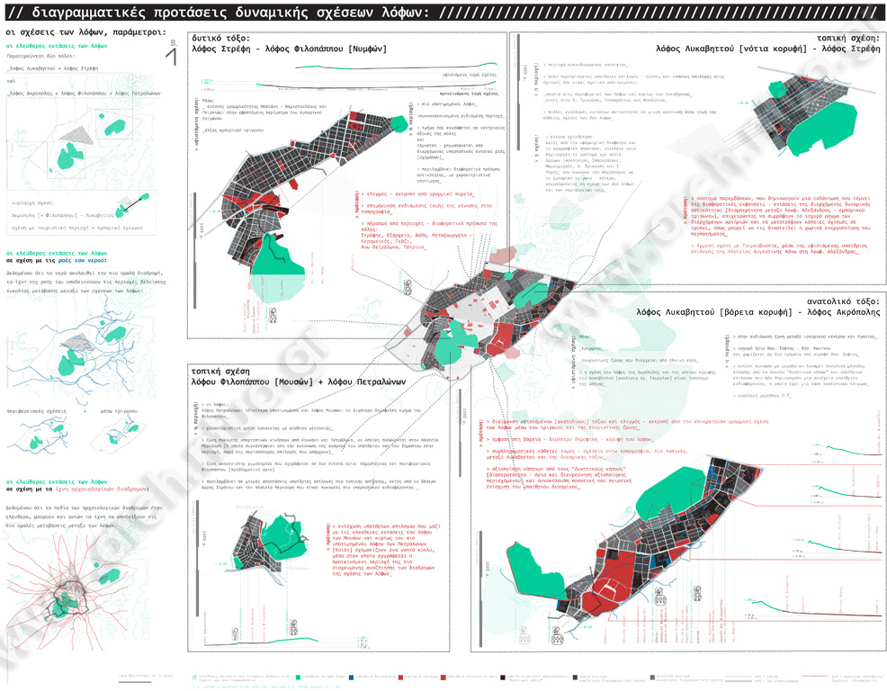
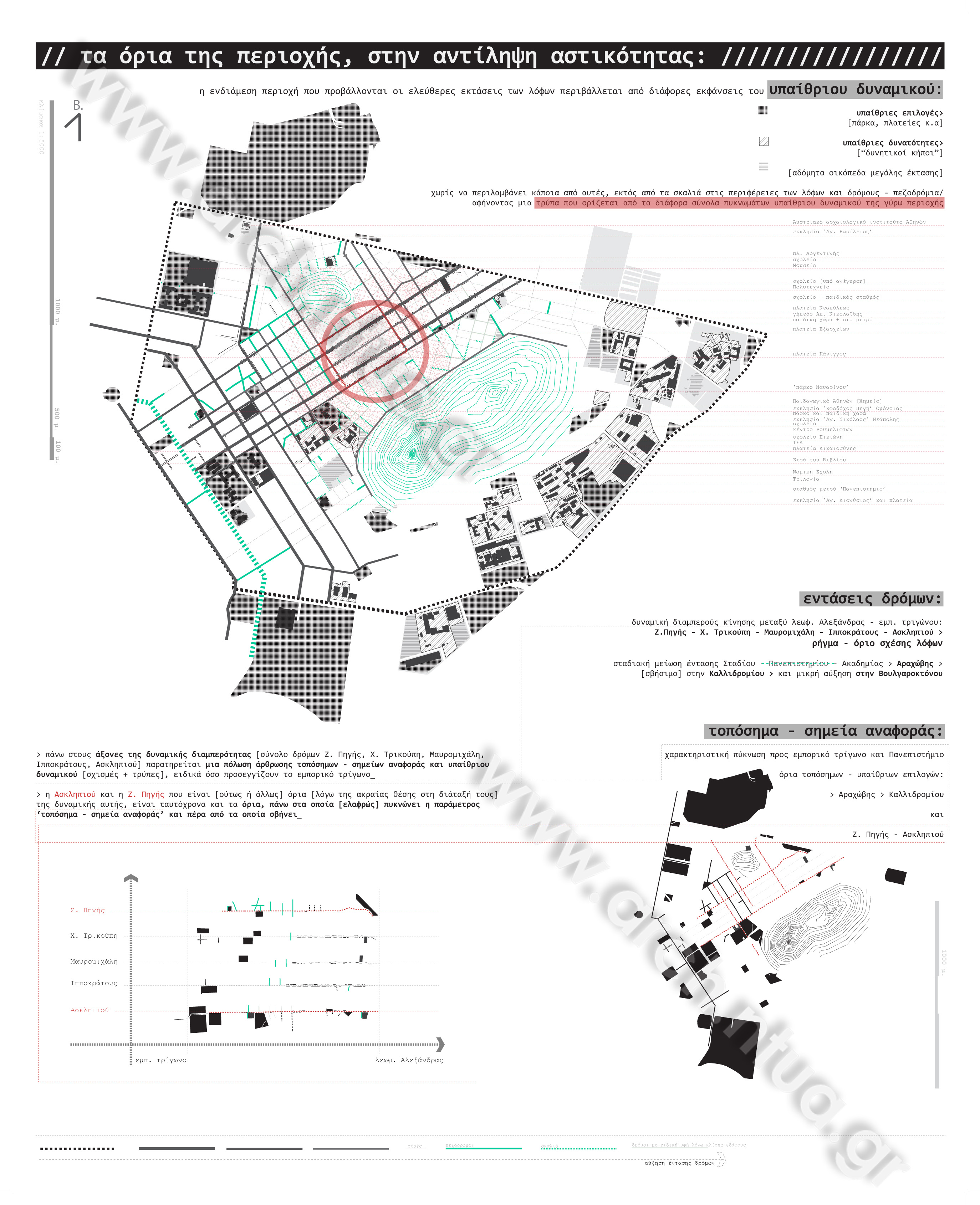
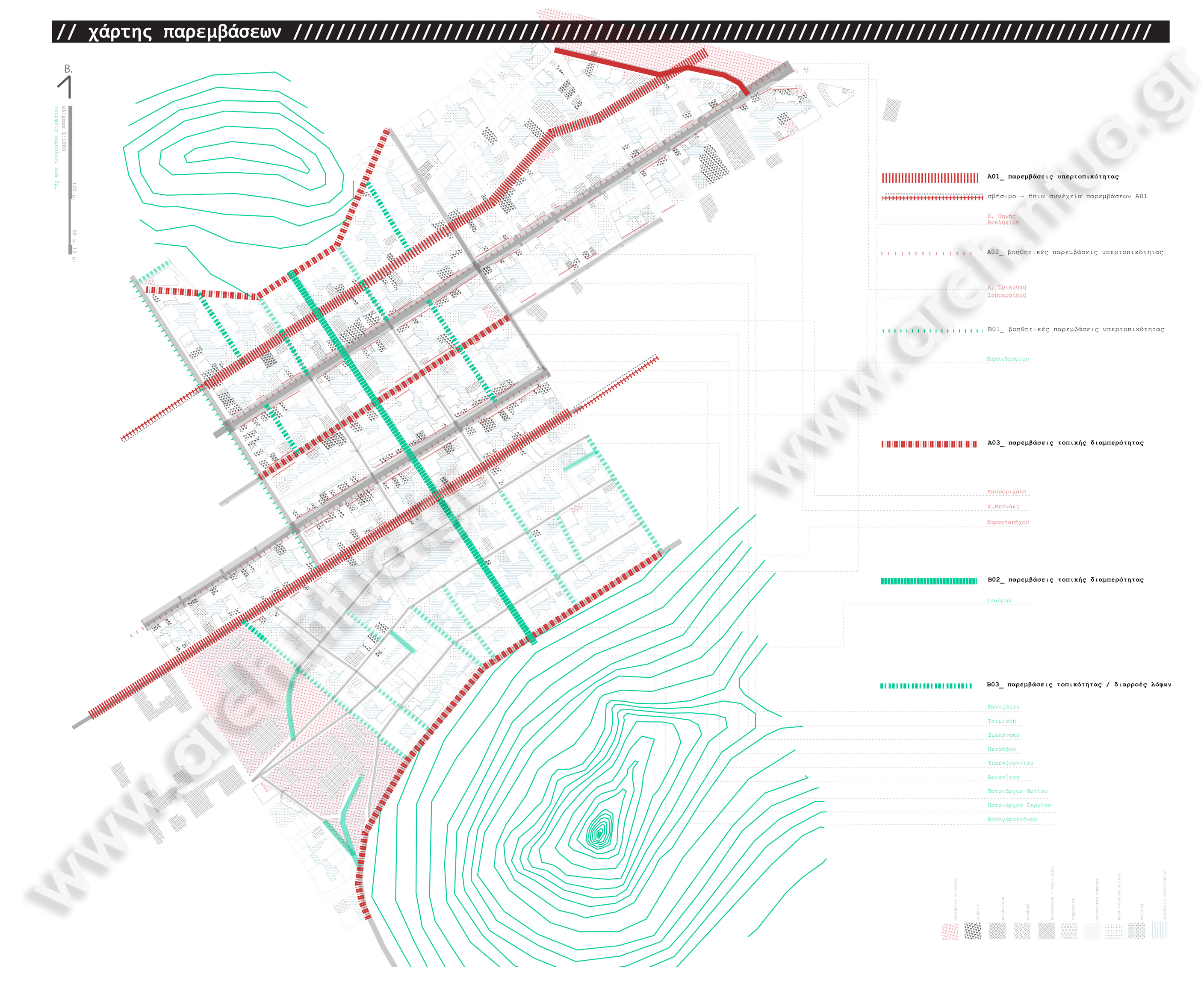
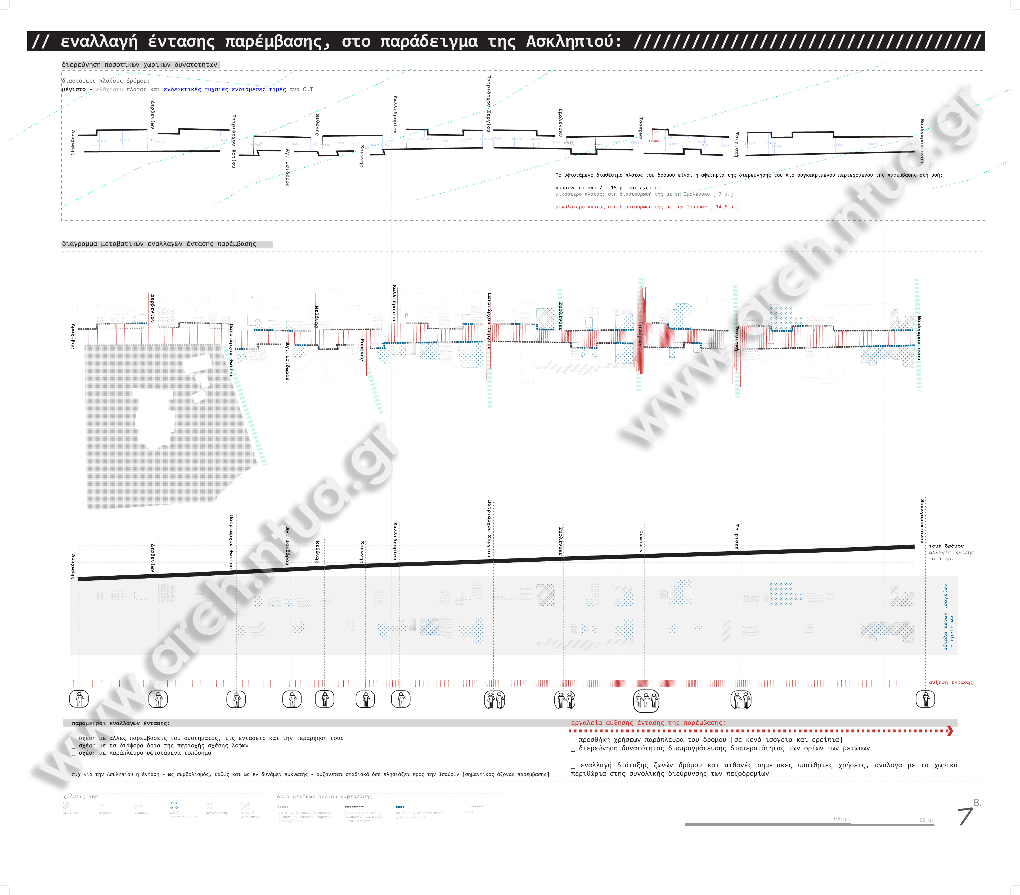
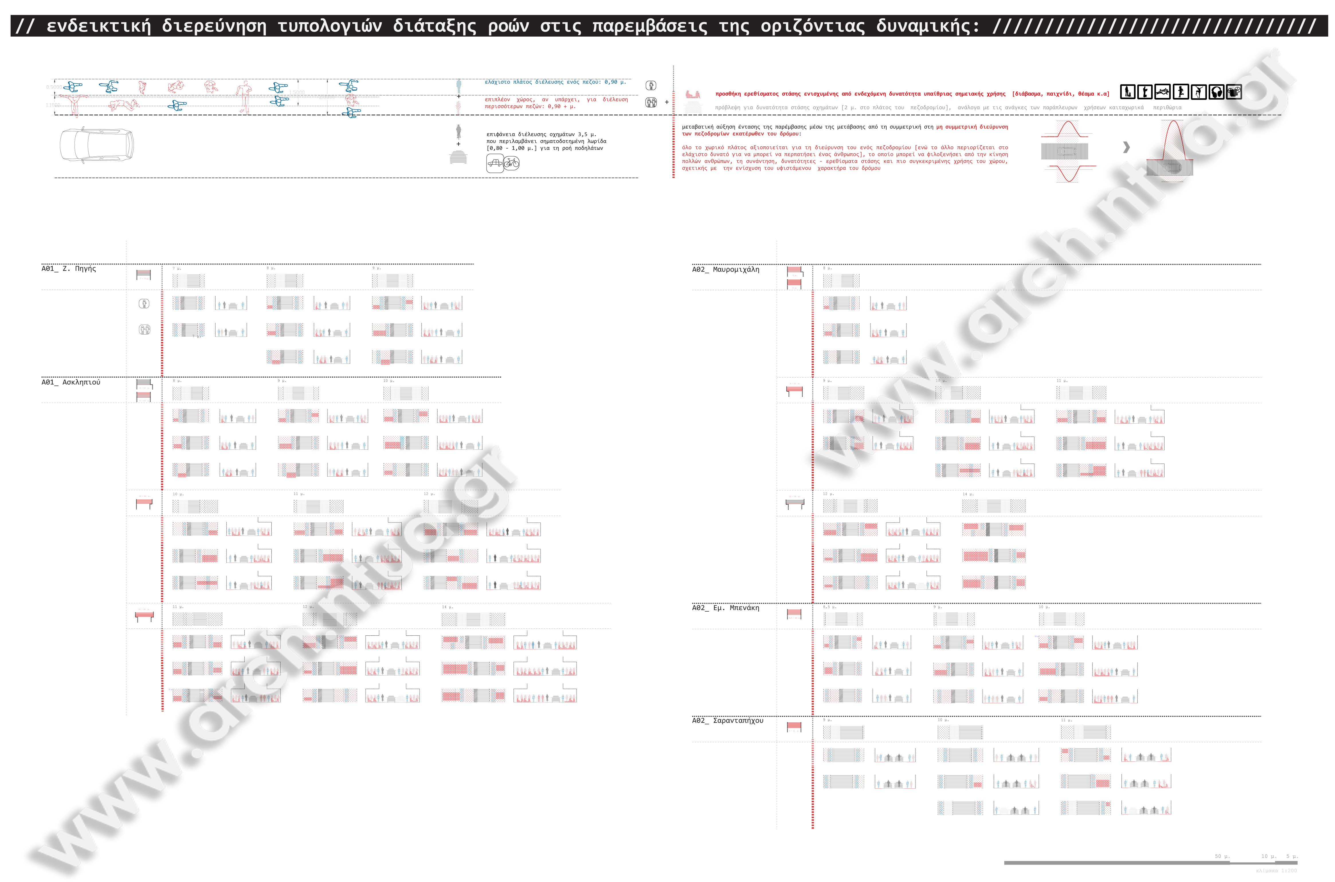
| dc.description.abstract | Η διπλωματική αυτή διερευνά το πως η ανάγνωση της πόλης μπορεί να λειτουργήσει ως εργαλείο επέμβασης στο αστικό πεδίο, εκτός από προϋποτιθέμενη διαδικασία του οποιουδήποτε σχεδιασμού, εστιάζοντας στο παράδειγμα της Αθήνας και πιο συγκεκριμένα, στην ευρύτερη περιοχή του ιστορικού κέντρου. Θεωρώντας το περπάτημα, το δημόσιο υπαίθριο χώρο και την τοπογραφία, ως κάποιες από τις βασικές παραμέτρους προσέγγισης, οικειοποίησης και της απαιτούμενης ‘κατοίκησης’ - πρακτικής - που ενεργοποιεί τις δημόσιες επιλογές και δυνατότητες της πόλης, διερευνά τρόπους ενθάρρυνσης του περπατήματος στο χαρτογραφημένο υπαίθριο δυναμικό, το οποίο παρεμβάλλεται μεταξύ των εξάρσεων του ανάγλυφου του εδάφους, με αφορμή τις σχέσεις των λόφων στο ‘κεντρικότερο κέντρο’ της Αθήνας. Αναζητά εργαλεία και στρατηγικές, μεθοδολογίες επαναθεώρησης του δημόσιου χώρου˙ προτείνει όρους, κατευθύνσεις και σχεδιάζει το σχεδιασμό, παλινδρομώντας σε διάφορες κλίμακες του αστικού – μεταξύ της εμπειρίας και της εποπτείας του χάρτη, μεταξύ του τοπικού και του υπερτοπικού, μεταξύ των διαφορετικών προσώπων της αθηναϊκής αστικότητας και των παραμέτρων που τη συνθέτουν. Τα διάφορα εργαλεία - προτάσεις βρίσκονται σε συνεχή αλληλεπίδραση με την πρακτική της ανάγνωσης – χαρτογράφησης. Μέσω της προτεινόμενης ‘κατοίκησης’, δηλαδή, παροτρύνεται και η ανάγνωση της πόλης, εκτός από το αντίστροφο. Ο κατάλογος των προτάσεων ξεκινά από τη θεώρηση του ευρύτερου πεδίου του ιστορικού κέντρου, υπό τους όρους του εννιολογικού πλαισίου, που προσδιορίστηκε, συνεχίζουν με διαγράμματα δυναμικών βελονισμού ορισμένων σχέσεων μεταξύ των λόφων Στρέφη, Λυκαβηττού, Ακρόπολης, Φιλοπάππου και Πετραλώνων και εστιάζουν σε ένα μεθοδολογικό παράδειγμα - εφαρμογή μιας διαδικασίας – μηχανισμού - αναζήτησης διαδρομών, με αφορμή μια τοπική ενίσχυση, μεταξύ του λόφου του Στρέφη και του Λυκαβηττού. | el |
| dc.description.abstract | This research deals with the possible role of the understanding – mapping – of the city, as a tool of intervention in the urban field, apart from being a presupposed process of every relevant project of design or planning. We focus on the paradigm of Athens and particularly, in its historical center. We consider walking, open public space and topography, as some of the most substantial parameters of the approaching, the familiarizing and the ‘dwelling’ of the city. Therefore, we explore ways to encourage walking in the open space, as being mapped at the intervals of the folds of the Athenian terrain; among the hills in the center of Athens, transforming their relationships into a motivation – a chance - to rediscover the city. This project searches tools and strategies, methodologies of reconsidering the concept of public space; proposes the framework, the guidelines and the directions of designing the urban design, including different perspectives – scales – of the urban realm between human experience and supervisory view of the city from the map, between the locality and the ‘hyper- locality’, as well as among the various shades of Athenian urbanism. The proposed mechanisms of urban desing activity are in continuous interaction with the act of analysis and that of chartography and mapping. In other words, the understanding - the sensing - of the city is being reinforced, through the ‘dwelling’ pursued, besides the reverse. The index of tools proposed begins from a consideration of the broader area of the historical center of Athens, in the conceptual context described above, and it continues with some experimental diagrams of acupuncture in the dynamics of the network of the relations among the hills of Strefis, Lycabetus, Acropolis, Filopappou and Petralona. A final ‘zoom in’ between the hill of Strefis and that of Lycabettus is being included, in order to explain a methodological application of the process of searching walking routes, in the local context of this version of neighborhood. | en |
| dc.description.statementofresponsibility | Αθηνά Σ. Σταματοπούλου | el |
| dc.language.iso | el | en |
| dc.rights | ETDFree-policy.xml | en |
| dc.subject | Aθήνα | el |
| dc.subject | Ανάγνωση πόλης | el |
| dc.subject | Χαρτογράφηση | el |
| dc.subject | Δημόσιοι χώροι | el |
| dc.subject | Τοπογραφία | el |
| dc.subject | Στρατηγικές αστικού σχεδιασμού | el |
| dc.subject | Υπαίθριοι χώροι | el |
| dc.subject | Athens | en |
| dc.subject | Mapping | en |
| dc.subject | Chartography | en |
| dc.subject | Public spaces | en |
| dc.subject | Topography | en |
| dc.subject | Urban intervention strategies | en |
| dc.subject | Open spaces | en |
| dc.title | Η ανάγνωση της πόλης, εργαλείο σχεδιασμού της: Αθήνα | el |
| dc.title.alternative | Η ανάγνωση της πόλης, εργαλείο σχεδιασμού της: Αθήνα | el |
| dc.title.alternative | The mapping of the city, as a tool of urban intervention: Athens | en |
| dc.type | bachelorThesis | el (en) |
| dc.date.accepted | 2012-07-18 | - |
| dc.date.modified | 2013-05-28 | - |
| dc.contributor.department | Εθνικό Μετσόβιο Πολυτεχνείο. Σχολή Αρχιτεκτόνων Μηχανικών. Τομέας Αρχιτεκτονικού Σχεδιασμού | el |
| dc.date.recordmanipulation.recordcreated | 2013-06-05 | - |
| dc.date.recordmanipulation.recordmodified | 2013-06-05 | - |
Αρχεία σε αυτό το τεκμήριο
Αυτό το τεκμήριο εμφανίζεται στην ακόλουθη συλλογή(ές)
-
Διπλωματικές Εργασίες [18960]


